
Must Have Apps for All Landscape Photographers
I have a lot of apps on my phone. Most people would probably say that I have too many, but one thing I have found is that many of them benefit my photography in some way or another.
As a landscape photographer in The Lake District, I am constantly using these apps to plan my shoots, to know what ungodly hour I need to set my alarms for (or how late I am going to have to stay up at night), see whereabouts the RAF and USAF are flying their jets and try and second guess if they will be coming through LFA17 where I can photograph them, decide whether I need to take a waterproof jacket or whether I need to make sure I have a hot drink available.
This isn’t intended to be a comprehensive guide to each of these apps, but just a quick overview of what it does and why it deserves a place taking up memory on my phone.
Let’s go!
Photopills
This is probably one of my most used apps, not just during the planning phase of my shoots, but also when I am out in the field.
Photopills is one heck of a useful app, and I think it is a must if you are taking your landscape photography seriously. It is loaded with a whole host of great features and these can do things such as calculate exposure times (really useful if you’re using ND filters to try and extend your shutter speeds), it will help you to calculate minimum focussing distance or hyperfocal distances and will help you to work out angles of view based on a number of variables.
The tools I use in here most however, are the planning tool and the map. These are really useful to identify places to go and shoot, especially if you are looking to shoot sunrise or sunset. These sections of the app allow you to see where the sun will rise, the arc it will travel through and where it will set. You can change the dates to see where it will be at a certain time in the future and then use this to help you plan. It also has a display that will show you where the Milky Way and the galactic core will rise and set, so if astro photography is your thing, this is a vital tool to help you to plan.
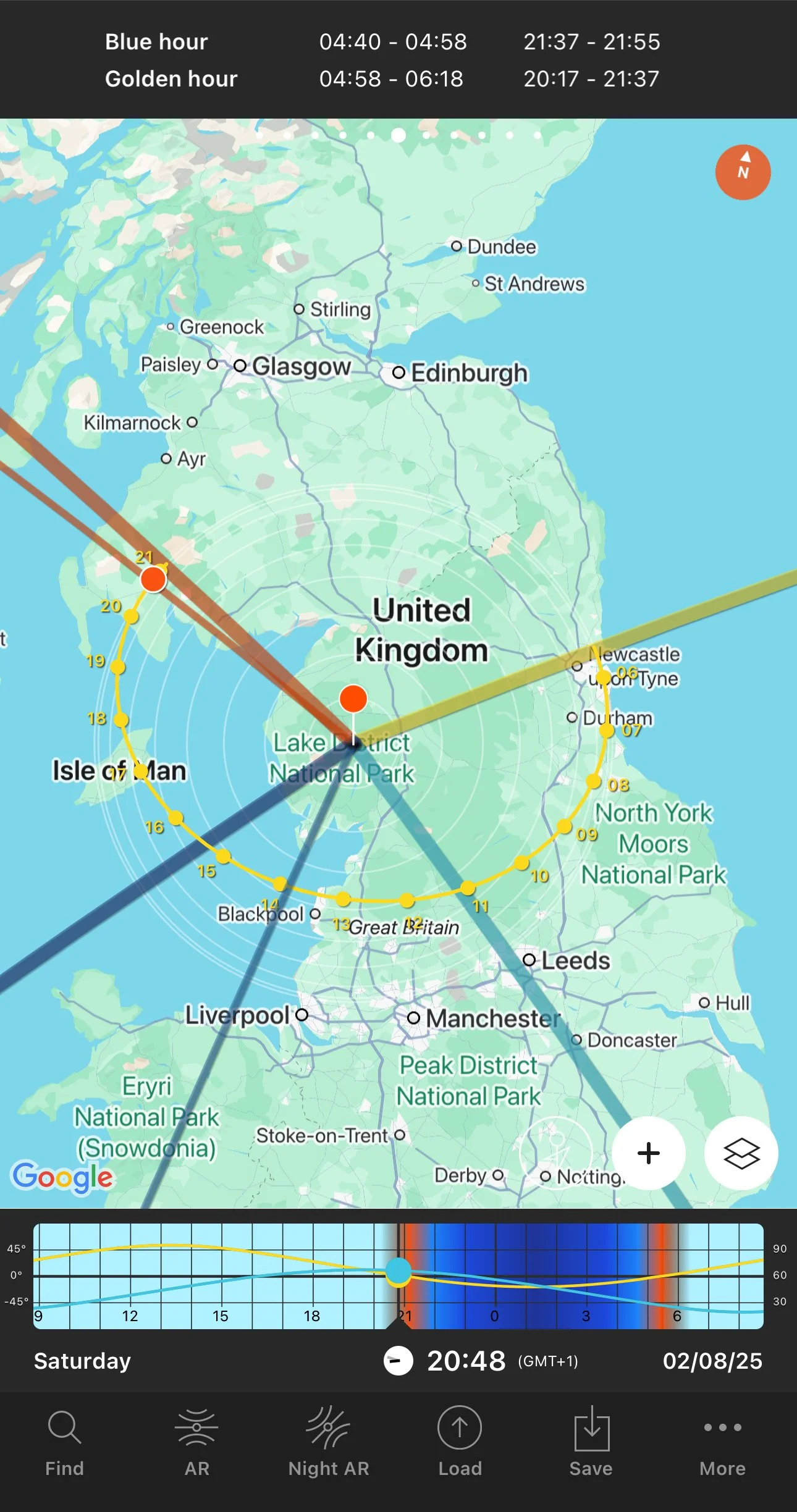
Another really useful section of this app is the “Sun” section, and this gives you at a glance information about when golden hour and blue are, as well as sunrise and sunset times for your location. I’ve included a screen shot of this to the left.
You can see the the yellow line for sunset, the orange line for sunrise and the path of the sun illustrated by the dotted, curved line. You can scrub through the time line at the bottom to get super accurate locations for the sun at any given point of the day.
This is a paid app (£10.99 one off purchase), but in my opinion, it’s worth every penny!
Lightroom Mobile
This offering from Adobe just keeps improving and it’s becoming quite the powerhouse. It makes editing on your phone much easier, clearer and quicker with each update. A lot of the things you are able to achieve in Lightoom on your computer can now be achieved just as easily in your phone. I have used this on phones with a variety of screen sizes, and must concede that the process of editing on your images is much better and much more accessible if you’re using the app on your phone. I have a Pro-Mac version of my current iPhone and this is about as small a screen as I would really like to use this app on.
Photoshop
This is another entry for Adobe into the list and again, it’s one that just keeps improving and getting more powerful. Whilst it is a great app, I don’t find it useful for doing things like drawing complicated masks or cutting out things with the pen tool. That said, if you want to use it to throw overlays on your images, or want to apply something like a gradient or just use the AI masks like sky and object selection then it’s nice to be able to do it on the go, but I must admit, I tend to break out the iPad and Apple Pencil to carry out anything that needs some finer detail applying as doing it on a phone is a bit too fiddly.
This a quick screen recording of photoshop mobile on an iPhone 14 Pro Max so you can have a quick look at some of the interface (no sound).
Weather Apps
I am going to lump these all into one section and will compile a list so you can see which ones I use. I don’t use all of them all of the time, but there a some which offer different bits of information that the others don’t. Even if you look at the same time on the same day on three different apps, they all might say slightly different things depending on where they get their information and how they put all of this together to display to you.
I used to really favour an app called “Dark Skies” as this adjusted what it was saying based on information it received from weather agencies as well as live user information about current conditions. Unfortunately, this app no longer exists as it was bought by Apple a number of years ago and much of the tech now appears within the Apple Weather app.
I’m based in the UK and we do love to talk about the weather, this I think is, in part, due to how changeable and unpredictable it can be!
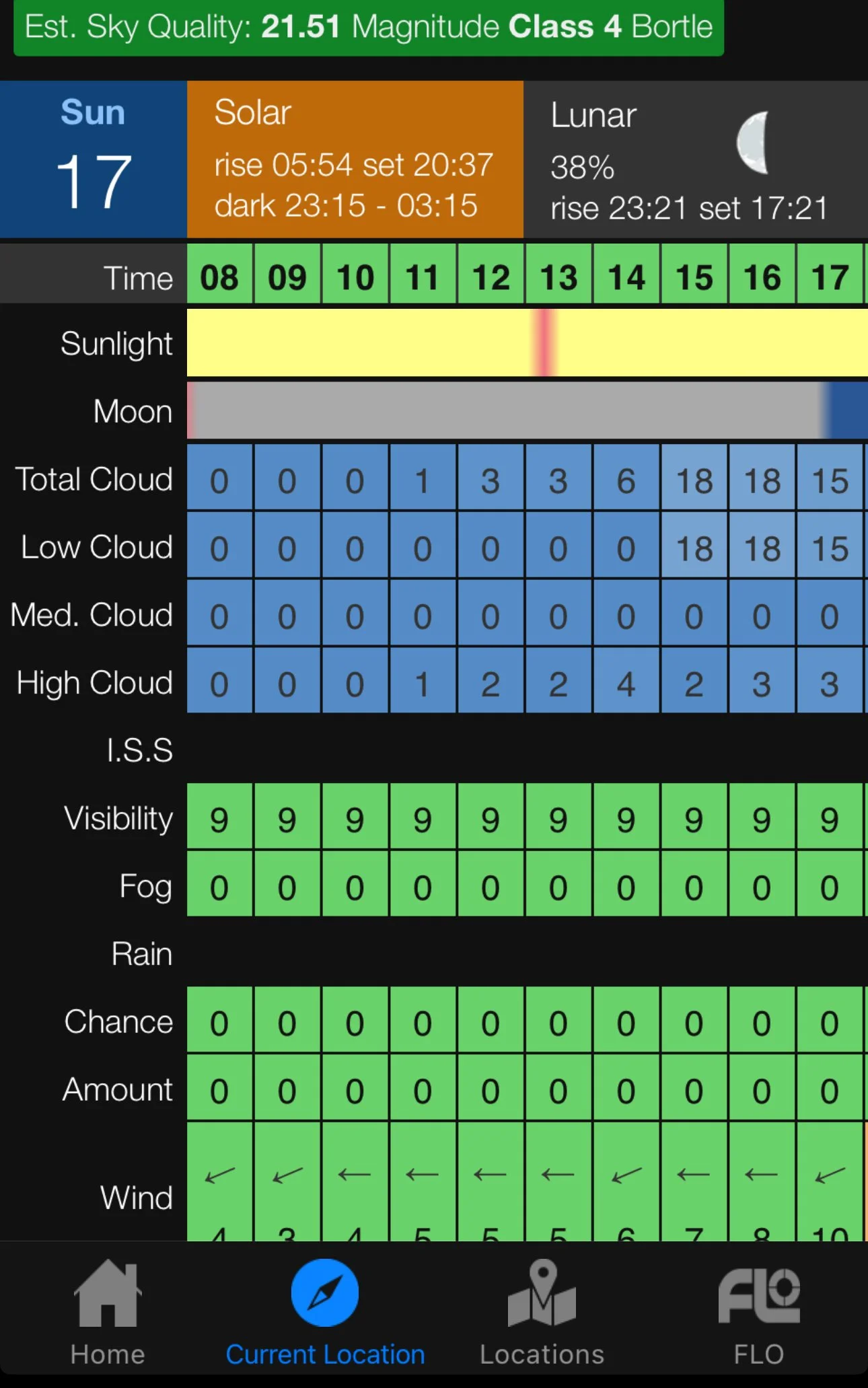
Some of the weather apps I am currently using are: BBC Weather, Apple Weather, Clear Outside (really useful as it tells me the dew point), Ventusky, The Met Office App (this is the the largest weather agency in the UK and is where the BBC gets its weather data from) and I have also recently installed Weather and Radar, which I am really enjoying using as it has some great, clear radar information which you can play through to check things like rain patterns and where cloud cover is going to appear, and when it will get there. I have found this to be really useful.
You can see a screenshot of ‘Clear Outside’ on the right.
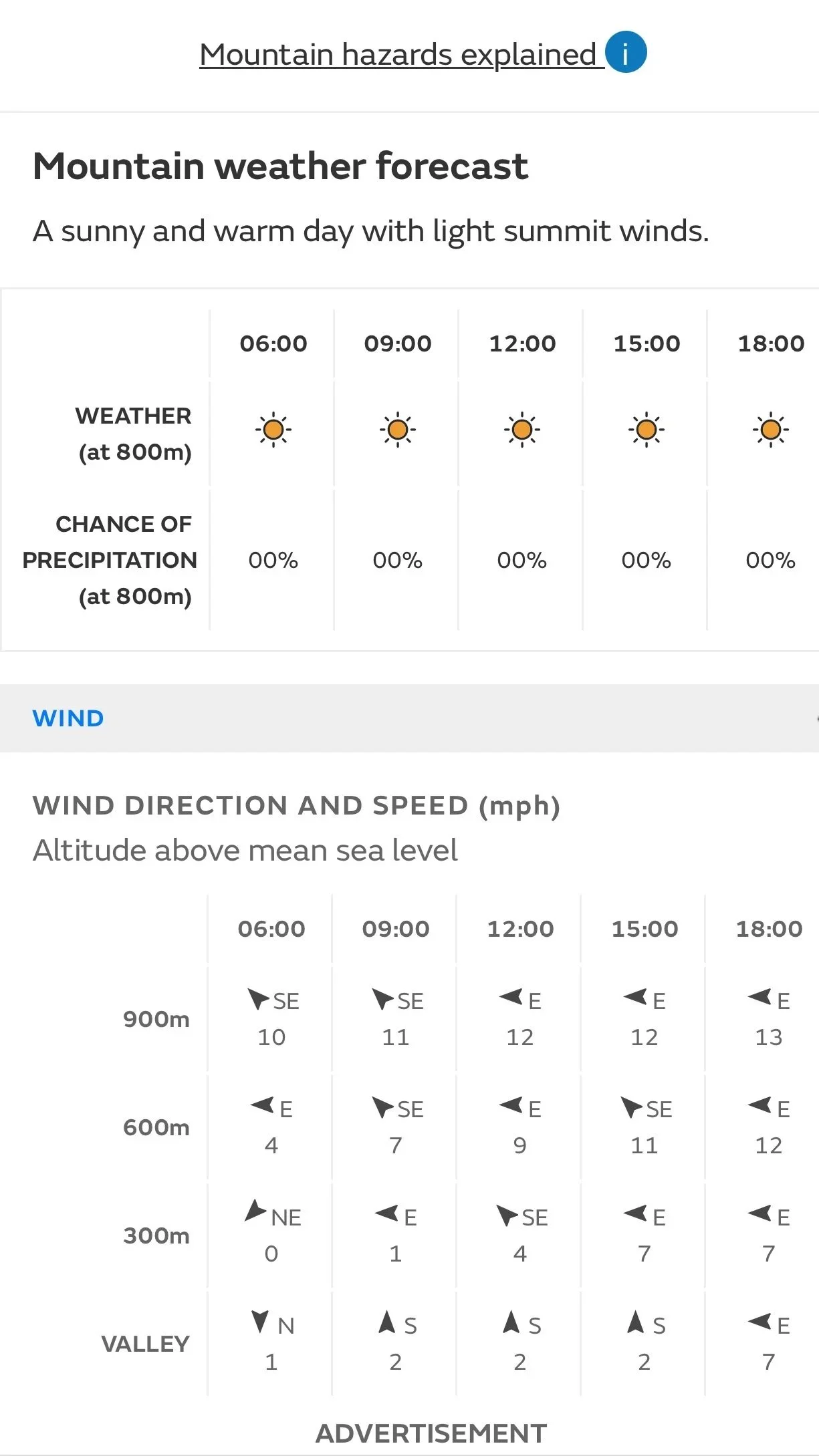
Although it’s not an app per se, I do have a shortcut to the Mountain Weather Forecast. Landscape photography in the Lake District could potentially be dangerous if you don’t check this app and you’re heading out climbing Wainwrights! The weather at ground level could be incredibly different when you’re high up in the hills and I would always recommend checking this out before you go out walking, especially in the fells. You can see from the screen shot on the left, even in the summer (this was taken on 17/8/2025) there is a 10mph difference in windspeed between the valley and then at 900m, so imagine what the difference can be be like when the bad weather has set in for the winter.
If you’re out doing landscape photography in the Lake District in the winter months, then you should also be checking the fell top assessor’s reports. These are compiled by experienced mountaineers, who climb to the top of Helvellyn every day, so that we can have accurate information about the state of the fell tops. You can see their reports by clicking here.
Space weather alert is another one I use, but more just to notify me about any solar flares or any other solar activity which may lead to the Northern Lights being visible near to wherever on the Earth I am. I don’t solely rely on this, but it triggers me to check some other sources. I am very lucky where I live to be part of a Facebook group which is run by some very knowledgable chaps who have achieved a level of ‘nerd’ that I can only aspire to and who are incredibly good at interpreting solar information from a number of sources.They use this to create clear and concise information if they suspect that there is a good chance you’ll be able to photograph the aurora, if you’re lucky enough to have clear skies!
Finally, if you’re a coastal photographer and like to get down onto the beach, then you should definitely have a tide times app for your locale on your phone and if you’re out in the same place regularly then you should buy a copy of the official tide times for that area, you can get these from most fishing shops or newsagents in places that are near the sea, and a lot of places will have them posted on noticeboards near to locations as you walk to access them. You don’t want to get caught out and be cut off by the tide, especially if it’s a fast moving one such as the one at Morecambe Bay or the Severn Estuary, and then need to be rescued. Be safe out there, you’re much more use as an alive photographer with no photos than what could be the very worst outcome.
And on that note, let’s move on.
Peak Finder
This is one of my favourite apps; it’s an augmented reality type app which helps you to identify which hills, fells, mountains, Munroes, Wainwrights etc. are laid out in front of you. All you do is install the app, and then when you’re on location, open the app, point your rear camera at what you’re looking at and it will scan the scene and label all of the major, named peaks in front of you.
I have found this really useful, particularly with some of the less well known fells and it’s helpful when I am writing engaging captions for my Instagram posts.
You can grab a screenshot of what you’re seeing on the app and save this for later when you’re editing and curating your social media captions.
Sky View
This is essentially the same process as Peak Finder, but this time you are identifying things in the night sky. Probably especially useful for astrophotographers, but my interest here is purely as a hobbyist. I do find it fascinating to see all of the satellites as well as the planets, the moon phase and the space station. Point it at the sky and watch the app label everything that you’re looking at, and follow the arrows/lines to see new things that are in view above the horizon.
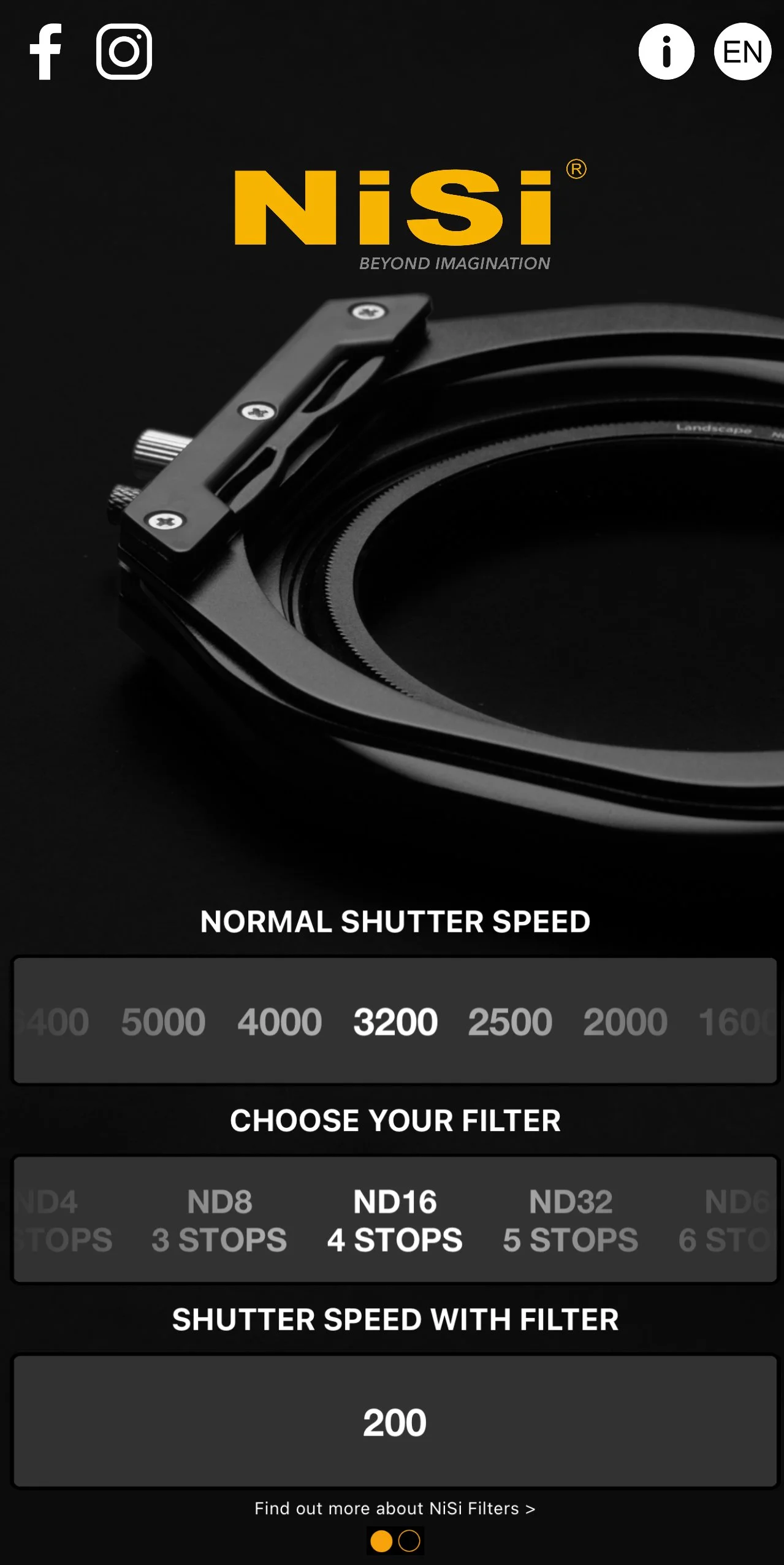
Nisi Filters App
I see this as a little bit like “PhotoPills light”, it purely exists to help you to calculate exposure times when you’re using ND or VND filters. Just plug in the the correct information and hey presto! Your exposure time will be calculated right in front of you - not necessarily ground-breaking, but great for quick and easy to input/read information to help you to nail your exposures.
Unsqrd
Unsquared is an app which I have found particularly useful given Instragam has so much hype about how its algorithm is working at the moment. What this app does (at least what I primarily use it for), is take panoramic photos and divide them up for you, into Instagram-friendly formatted images that are constrained to Instagram’s square crop ratio. This allows you to create a seamless carousel style post which will allow your followers to enjoy your image (almost) as you intended.
However, this does mean that you will be posting the image as a carousel style post if you’re sharing it on Instagram. According to most of the information I am seeing online, carousels are a great way for you to leverage the algorithm in your favour as it means that people will spend longer on your post. Instagram themselves have said that they will be updating their insights panels soon too, this will give you a better understanding of how people are interacting with each of the images that you are sharing as part of this carousel.
Flight Tracking Apps
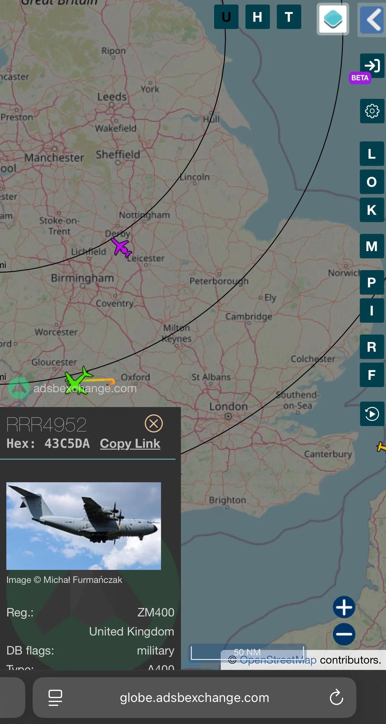
I have the Flight Radar 24 app installed on my phone, but find myself increasingly reaching for ADSB exchange. I am lucky enough to live in a part of the world where the RAF and USAF do a lot of low level flight training, and even luckier to live somewhere that regularly sees planes flying low right by my house.
Having access to the information which allows me to see where and what these aircraft are (usually Typhoons, F15s and F35s, Hawks, Texans, and less frequently the huge cargo style planes such as the C17 Globemaster and if I’m really luck, The Red Arrows).
I haven’t taken any aviation shots that I am happy enough with to share yet - I still need more practice, but having this information at my fingertips lets me know when I might get a lucky shot if I can get out in to the garden to shoot.
ADSB exchange has become my most frequently used app of this type in the last 3 or 4 months as it has easy to set and remove filter options which makes the military planes easier for me to predict.
The screenshot on the right is from adsbexchange.com. Clicking the ‘U’ button at the top filters out everything bar military flights and then clicking the aircraft icon for a particular flight opens up the panel in the bottom left corner which tells me exactly which plane I am looking at and gives me some more information. Bear in mind that this is the military so not every single flight they have going on is going to display in this app!
I’d also recommend checking social media for groups that are local to where you live or where you shoot as you can get up to date information from aviation photographers who are often at airbases watching them take off and scanning the frequencies to see where the pilots are headed based on their radio conversations!

Blackmagic Cam
This is my go to for when I need to record video and I want some more control than my camera app gives me. It does a lot of stuff that the iPhone camera app does, but the controls are much more easily accessible when you’re shooting with this app, so you can change shutter speeds to match what you’re doing, or to try something more creative.
This app also allows you to add codecs to your video and includes HEVC, (H.265), H.264, all of the standard Apple Pro Res codecs, all with bit rates up to 54MBPS.
You also get a choice of colour spaces - rec.709, rec.2020-HDR and P3 D65.
I think the thing I like most about this is that all of the controls are on the screen, along with a clear histogram and an audio level so that you can make sure that you’re audible but not clipping.
Using this app when shooting on a gimbal, for me, makes my life a bit easier by virtue of the fact that I am able to access the settings quickly, to get the exposure and the effect I am looking for.
I don’t shoot a ton of video, (I should do more), but having something which is this easy to use makes it much more straightforward for me when I do.
There might be better apps out there, but this is one that suits me and that’s why it gets to stay on my phone. It is also a Blackmagic app, so the integration of the files with DaVinci resolve is seamless, making the editing a bit of a dream.
It doesn’t shoot a true log profile, check out Filmic Pro if you want something that gets close to that, but this does come at a cost of £9.99 a week or about £30 for a full year’s subscription.
So there you have it…
These are some of the apps I have on my phone that I use in my day-to-day when doing landscape photography in the Lake District (and beyond!). Some of them get a lot more use than others, but they are all a vital part of my workflow. The important thing with these apps is to find what works for you, we all have different preferences and ideas about what we want to get out of our apps, and we all use them in slightly different ways. The apps I have written about are what work for me, you’ll need to find what works for you!
All of the apps I have talked about here are installed and up to date on an iPhone Pro Max on 17/08/2025.
If you’re heading to the Lake District and want to test out PhotoPills at sunrise or sunset, then be sure to check my blog on where to shoot sunrise and sunset in The Lake District.